The mountain region southeast of Cusco, known by locals as the “Nudo de Vilcanota”, is the second largest glacier system in Peru. Located between the Peruvian departments of Puno and Cusco, this range has over 30 peaks above 18,000 ft. / 5,500 m., glacier lakes, and a unique feature: the Quelcaya Ice Cap. This geological formation is almost 13 km long and 4.5 km wide. There are only two ice caps in the tropics, the Quelcaya and another much smaller one, located on the island of Java, in Indonesia.
The importance of ice caps is well known, they are unique witnesses of seasonal variations that allow studying the climatologic changes all over the world. Micro-particle studies of the Quelcaya ice were used to create a map of weather patterns of the central Andes over the last 10,000 years.
The landscape is doted by llamas and alpacas, owned by the shepherding communities that populate the area for centuries. Non-domesticated vicuñas (one of the four American cameloides) and other wild life can often be observed near small Andean lakes, of course, all amidst unspoiled nature and hiking routes off the beaten path.
Early morning departure by bus along the fertile Vicanota valley to the town of Checacupe from where we start ascending to Pitumarca. Following the spectacular Japura gorge, we reach a place called Congomiri (13,000 ft. / 3900 m.), the trailhead for our unique trekking experience “Camino del Apu Ausangate” Llamas will carry part of your personal equipment. Gradually we will work our way up through a picturesque valley where you can appreciate some of the highest potato cultivations in the world. The landscapes change dramatically as we leave the last houses behind us until we get to the Anta pass (16000 ft. / 4900 mt.) with first fine views of the Vilcanota range. Overnight stay at the Huampococha Tambo
A spectacular part of the trail finds us hiking in the middle of mountains with red, ochre, and blue strata. This section offers a glimpse of marvelous geological wonder and natural beauty. Frequently groups of gracious vicuñas and deer can be spotted in this isolated area dominated by the mighty Ausangate mountain. Accommodation at the Anantapata Tambo.
Tremendous views of the glaciated south face of the Apu will inspire us as we continue towards the red sandstone formations of the “Nevado del Inca”. After a demanding ascent of the Palomachayoc pass at an elevation of 16,500 ft. / 5,150 m. we will hike down to the Machuracay Tambo, the highest lodge in the world (15,700 ft. / 4,800 m) right at the foothills of the Apu Ausangate.
The first approach in the foothills of the mighty “Apu”. Following the moraines, we will reach a section of the South East Ridge and after some scrambling, we will negotiate our access to the glacier, which allows us to become more familiar with our ice climbing tools. At approximately 17,700 ft. / 5,400 m we will determine the location of our “high camp” and deposit the equipment. In the late afternoon, we will be back at Machuracay Tambo.
Today we will rest in the base lodge and prepare ourselves for the accent by checking the equipment, doing some technical training, and observing the route.
Early in the morning, we will take the route that leads us back to the glacier. After reaching the “high camp” and enjoying a picnic, part of the group will install a static fixed rope on the mountain wall, while other members are assigned to prepare the camp for the night.
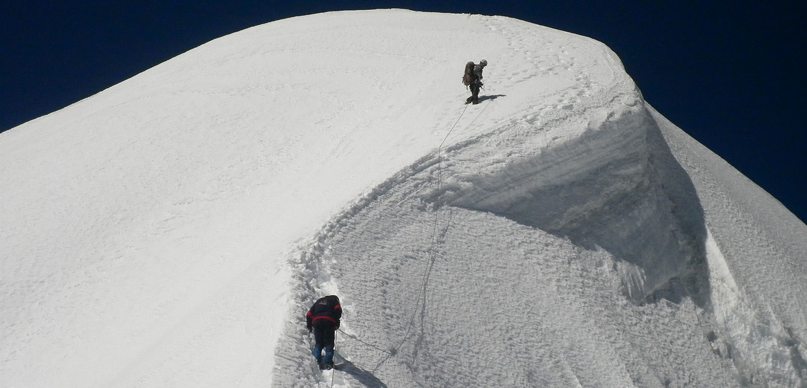
We will be getting ready at 3 am and by daybreak, we should start for the accent on the fixed rope. This section will give us access to the high, groundless snowfields (using snowshoes) on our way to the so-called “cumbre falsa” (or “fake summit”), before we finally reach the top of the Ausangate (20,945 ft. / 6,384 m). In the afternoon we will work our way down to lower ground and decide whether to stay another night at the “campo alto” or at Machuracay Tambo
According to our decision on the day before, we will either decent first from “campo alto” to Machuracay and continue to Chilca Tambo, or we could hike directly on rolling hills and pasture lands for alpacas from Machuracay to Chillca, where we can choose to spend the night in our comfortable “tambo”, or to leave for Cusco.
After a final short walk, our bus will be waiting to take us back to Cusco.